
Disable anything container related to see if this is the reason. If it behaves differently without containers, you will know that you have to search in this direction.
- 6 Posts
- 251 Comments
Joined 2 years ago
Cake day: June 15th, 2023
You are not logged in. If you use a Fediverse account that is able to follow users, you can follow this user.
I use the google container, and it behaves like this deliberately. If you click on a link on a google page it opens that page outside of the google container. Try to disable/reinstall container related addons

 14·1 month ago
No.
A developer kit is available, but only for R&D teams: https://www.etherdyne.net/evalkit
 7·2 months ago
Yepp, Hanlon’s razor: they are mostly just lazy and maybe incompetent, not necessarily evil, that’s just a side effect. E.g. in my country if you call them that you want to get out of CGNAT they’ll just do that for you. My IP haven’t changed in years, but I don’t pay for fix IP. But it may be different in each country, I have mostly good experiences with local ISPs here.
 1·2 months ago
On a lot of places it’s forbidden to light campfires outside of designated areas.
While Shelly wifi devices can use their cloud, it’s optional. By default cloud is disabled, you can even make them report to your own MQTT server.

How can you be sure someone is not storing CSAM on your server, if it’s encrypted?
It sounds like storj from a decade ago, but you got at least some monopoly money for your storage there. I don’t follow what they are doing nowadays but it started similarly
You can try the hosted version here: https://app.nocodb.com/
Have you checked nocode platforms/databases? It’s basically a cross section of a super powerful excel and a database manager. You can set up the way you want, link records from different tables, add images, files to “rows”, like excel on steroids. You don’t have to understand SQL at all, that’s why it’s called “no code”.
I use nocodb. Tried baserow before, but I didn’t like that a lot of basic features are not available in the foss version, in nocodb only some bells and whistles are behind a paywall and not available in the self hosted version
They are also called airtable clones, as airtable was the first well known platform like these.
Some other similars exist: https://alternativeto.net/software/airtable/?platform=self-hosted&feature=database-management
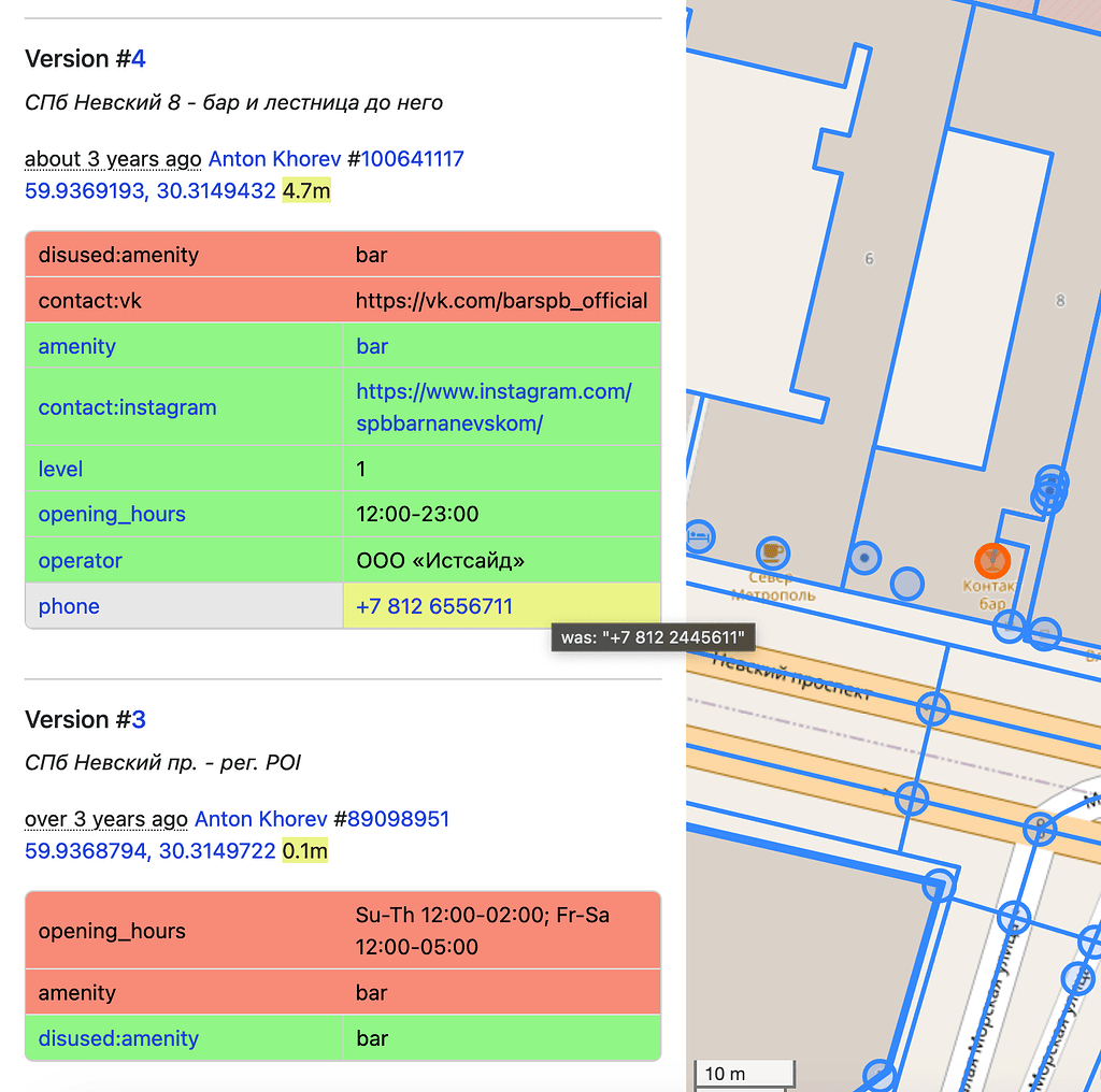
OpenStreetMap is the registered trademark of OSM Foundation, and they ask to please don’t use mixed and confusing names like some of these for related projects. From the Trademark Policy:
You may not:
abbreviate the wordmarks, combine them with other words (“OpenStreetMapThing”), or substitute words in the mark (“OpenStreetThing” or “OpenThingMap”), especially where the new combination sounds similar to OpenStreetMap.
While they usually allow the use for open projects, it would be just easier to respect the request of the Foundation.
Sorry for copying my comment from the other thread, but it could help others here as well.
You have to draw them only once, than you can use the tag
repeat_on, and list the levels: https://wiki.openstreetmap.org/wiki/Key:repeat_onBut yes, it’s super micro mapping, I would map this only, if the full building is mapped with the same detail level.
“Ideally”, yes.
If you use simple indoor tagging, you can use
repeat_on, and you can map this with a single line: https://wiki.openstreetmap.org/wiki/Key:repeat_onThere are some renderer support for it, I’m not sure any routing engine supports this.
 1·3 months ago
Those snakes seemed very sedated. A lot of animal abuse may be behind the scenes, they show the small room where the hyena lives, it doesn’t look big enough for an animal of that size.
The pin runs some android based software as the website mentions adb. You can build your own interposer, and they are selling the current official one on Etsy, in a 3d printed case.
It doesn’t sound like something made in a factory. I guess it uses some off the shelf usb to jtag chip or similar.The interposer files are in this repo: https://github.com/MaxMaeder/OpenPin
From the bom it seems it’s just a micro usb to pogo pin converter, no chip mentioned, so the pin has an usb port, but pogo pin form…
Small and easy to wear form factor, monochrome laser projector are the two most interesting. Also a camera, microphone, a lot other sensors, packed in a tight case. If you build something DIY usually you can’t make it this small.
This is not a well written arricle. They mixes up material design with corporate memphis, which is not necessarily related, they can exist independently.
Their actual problem with google’s ux appears only in this paragraph:
The problem? Google’s actual UI & UX design is terrible. Whether mass-market or enterprise, web or mobile, its interfaces are chaotic and confusing. Every time I use Google Drive or the G Suite admin console, I feel lost. Neither experience nor intuition helps—I feel like an old man seeing a computer for the first time. I used Android for years (stock Android on a Nexus device), yet even after all that time, I struggled to distinguish buttons from plain text.
No examples, no reasoning, no good counter examples how it should be done, nothing. I’m not super familiar with google’s web ux as I only use search and youtube ocasionally. They write here about android, but no android screenshots in the article. So is this about web ux only? Or anything google? The author couldn’t even figure out what is their problem, this article sounds like “old man yells at cloud”
To activate a Link Preview, hover over a link and press Shift (⇧) plus Alt (Option ⌥ on macOS),
Thanks god it’s not default.
They tried to place them as far from villages as possible for the first one. You can see in the video, the guy had to bike to the middle of nowhere to record it. The problem first appeared in countrywide news after the 3rd one, because that’s much more closer to some residential buildings.
Hungary is not a classic democracy, if you are not a friend of a local oligarch you can’t really do anything about things like this. If they decided about it at the HQ it will happen whatever it takes.
I think the original concept is not inherently bad, you just need careful planning and sound simulations. Current tech can simulate sound waves very precisely. Maybe such a small country doesnt need 3 of these, they should have stopped after the 1st or 2nd one


It’s an interesting video, you can see the sizes and form factor of the recievers this way much better. You can still skip the parts you are not interested in.
The quick start guide from the link in the description if you just want to read numbers: https://static1.squarespace.com/static/669856991b982007b8a6a788/t/67af70bd5fc318472e2f9f1a/1739550910959/Evaluation+Kit+-+Quick+Start+Guide.pdf